Abuttals - significance of the surrounding titles
In the relocation of titles bounded by abuttals surveyors should comply with the established rule of law known as the 'rule of abuttals:'
'A description by abuttals will, as a rule, override measurements expressed in figures if conflict exists between description and measurement'.
See also Small v. Glen (Victorian Law Report, Vol 6, Page 154)
The surveyor must ensure that the survey adopts a common boundary with the adjoining parcels. Instances have occurred where the adoption of measurements only has resulted in either a hiatus being created between titles or the titles overlap.
Alignment - the effect on subdivision
A common source of error in relocating title boundaries is caused by ignoring the effect of alignment on side roads. Where a subdivision has been so affected by alignment (or re-alignment) it is the accepted rule that it affects the parcels adjacent to that alignment only, ie where alignment of the side roads has occurred subsequent to the base subdivision any gain or loss of land will accrue to or be borne by the adjacent parcels only.
Excess or shortage in measurement
If excesses and shortages in dimension are disclosed in a new survey every effort must be made to ensure that adjoining and other properties within the base subdivision have sufficient land to satisfy their entitlement. Careful consideration must be given to the intent of the original subdivision. For example, if parcels show equal frontage, every effort should be made to retain this relationship. However, the final decision on the boundary fixation will also be affected by:
- the position and age of occupations
- the relationship of monuments
- the standards of measurement applied over the years.
It requires substantial evidence to justify the inclusion of an excess in a title if doing so will re-locate the boundaries outside the existing occupations. However, it should be noted that the continued adoption of original title dimensions for each lot will have the unsatisfactory effect of moving the excess through the subdivision until it eventually becomes located in the last remaining lot. It may be desirable to apportion the excess or shortage between established corners.
Rear boundaries
Where lots facing parallel roads have a common rear boundary, and no supporting evidence is available to fix the boundary, the surveyor may have to refix both roads to verify the existence of any excess or shortage over the original dimensions. This enables the line of the rear boundaries to be re-established from end to end, avoiding the creation of 'steps' in the rear line of adjacent lots.
Depths of lots can be affected by a change in the position of the road by either acceptance of a different definition upon resurvey or by alignment of the road after the original subdivision. Original depths should not be adopted from a road without verifying that the position of the road is the same as shown in the original plan.
Occupations
In the absence of satisfactory original markings, probably the best evidence of the boundary position is by the occupations on the subject land and nearby parcels. In these situations all occupations should be measured along the road frontage and as many as possible along the rear lot boundaries and comparisons made with the original dimensions of the lots before a decision can be made. If this method is used to refix the boundaries the age and nature of the occupations must always be added to the plan.
While long and undisturbed occupation provides strong evidence that the occupations are erected on the boundary as originally laid, it is not indisputable. Further supporting evidence should be sought.
Boundaries defined by physical features
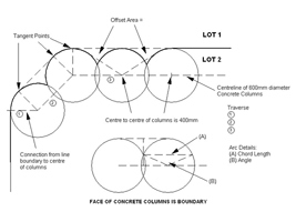
It is possible for new lot boundaries to be defined by a physical feature. An example is a plan where the lot boundary is positioned along the face of a line of 600mm diameter cylindrical concrete pilings the linear boundary is formed by a series of secants along part of the face of each piling.
As conventional definition of the boundary (arcs, chords and radii) would be cost prohibitive and the amount of information extremely difficult to show on the plan, it is necessary to define the boundary by a traverse through the centres of the pilings and show typical profiles of the pilings in the manner set out on diagram - click on diagram to enlarge.
Detailed diagrams showing the arc details, connections, intercepts and offsets from the centreline traverse are required for each change in angle, each change in diameter of pillar and each end of the secant wall. The diagrams should also indicate the number of columns and their relationship to the corners of the parcel.