Roads and Maritime Services areas
Port Jackson, Botany Bay, Port Hunter and Port Kembla
Roads and Maritime Services is the proprietor of the bed of Port Jackson (Certificate of Title Volume 5018 Folio 1), Botany Bay, (Volume 11187 Folio 94), Port Hunter (Volume 13075 Folio 200) and Port Kembla (Volume 15268 Folio 62). The Roads and Maritime Service must approve the definition of the MHWM where boundaries are formed with these titles. The relevant statement (signed by an authorised officer of Roads and Maritime Services) must be added to the plan.
Note Land reclaimed from bed of the Port of Sydney but not granted or alienated is vested in Roads and Maritime Services vide Proclamation in Government Gazette dated 13 June 1901.
Approval is not required where a boundary is defined in a plan on public record by a monument such as a seawall or a limit line for reclamation. See also the February 1991 edition of 'Azimuth'.
Any accretion to land adjoining must satisfy the requirements of the Modified Doctrine pursuant to s.55N Coastal Protection Act 1979.
By agreement with the Roads and Maritime Services, the Registrar General accepts the approval of the Authority as indicating that it is satisfied, after examination, that the definition of mean high water mark of the respective ports is also the definition of the Marine Ministerial Holding Corporation's title boundary.
Titles to any land formerly in the name of The Maritime Services Board should issue in the name of 'The Marine Ministerial Holding Corporation'.
Tidal lakes
It is doubtful whether there are any lakes in NSW, which have perceptible tides, the so called tidal 'lake', (e.g. Lake Macquarie) actually being an inlet of the sea. Most coastal lakes or lagoons have, at one time or another, been closed off from the sea and accordingly are classified as non-tidal.
The following coastal lakes or lagoons in this State have been considered by the Courts to be non-tidal:
- Narrabeen Lagoon (State Report Vol.45 page 321)
- Dee Why Lagoon (Commonwealth Law Report Vol.10 page 341)
- Lake Illawarra (State Report Vol.21 page 408) the court ruling affects part of the lake and a tributary
- Glenrock Lagoon (State Report Vol.5 page 157)
Note Where the Courts have ruled part of Lake Illawarra as being tidal, a 30.48 metre Crown Reserve may also affect the parcel(s). See Memorandum AF78929.
Title to the bed of all other tidal waters
Title to the bed of all other tidal waters (unless the subject of a Crown grant) is vested in the Crown, i.e. 'The State of NSW', under the control of CrownlLands on behalf of the Minister Administering the Crown Lands Act 1989. An exception is those tidal waters (and any inter-tidal zone) vested in the Minister Administering the National Parks and Wildlife Act.
Locating or relocating tidal boundaries
The following points must be observed by a surveyor when locating or relocating a parcel boundary defined by the MHWM and when showing that boundary on a new plan of survey:
- reference to 'high-water mark' (or other boundary of land that abuts tidal water) in a previous plan of survey is taken to be reference to 'Mean High Water Mark' unless otherwise stated - cl.51 Surveying and Spatial Information Regulation 2012.
- the description and relationship to the MHWM of any sea wall and reclaimed land must be shown in a new plan of survey - cl.51 Surveying and Spatial Information Regulation 2012.
- the landward boundary of an existing reservation of stipulated width fronting tidal waters which has not been previously defined by survey must be defined by right lines approximately parallel to the MHWM as originally defined - cl.48 Surveying and Spatial Information Regulation 2012 - see page on Landward boundary of road or Crown reservation abutting a waterway.
An assessment must be made as to whether the location of the MHWM is identical to that shown in the previous survey(s) or whether accretion or erosion has taken place. Any accretion will invoke the provisions of the Coastal Protection Act 1979 (see below).
Deposited Plans adjoining tidal waters will only be registered in NSW LRS if Crown lands or Roads and Maritime Services approval to the definition of the Mean High Water Mark is supplied or has been specifically approved in a previous plan see Consents to natural boundaries page.
Under existing legislation NSW LRS has no authority to waive the requirement for obtaining a consent, however, the Minister has given permission for certain concessions. These apply to a plan:
- of partial survey where the lot containing the position of the MHWM is a compiled residue lot
- that defines the MHWM in the same location as a Crown Plan, and/or
- that defines the MHWM in the same location as an existing registered plan and the definition in that plan has the required consent(s).
Coastal Protection Amendment Act 2002
The Coastal Protection Amendment Act 2002 commenced on 8 February 2003. If the land is located within the 'Coastal Zone' or adjoins the tidal waters of Sydney Harbour or Botany Bay, Part 4B (s.55N Modification of doctrine of erosion and accretion) Coastal Protection Act 1979 prohibits all determinations of the Mean High Water Mark where the parcel of land adjoining would increase in area where:
- the accretion is not likely to be indefinitely sustained by natural means, or
- public access to the waterfront will, or is likely to be restricted.
Maps outlining the Coastal Zone are available for inspection at the principal office of the relevant Local Government Authority or the relevant regional office of the Department of Planning & Environment www.planning.nsw.gov.au.
Note 1 NSW LRS provided a concession whereby new plans dated between 8 February 2002 and 8 February 2003 that bear the original consent (i.e. without reference to s.55N) could be accepted and processed. Any consents prior to 8 February 2002 must be returned to the consent authority for review.
All plans lodged after 8 February 2003 must bear the statement as shown in the Consents to natural boundaries page.
Note 2 Section 55N does not apply to the amendment or redefinition of titles that were previously based upon poor, erroneous or inaccurate surveys. For further information see Appendix A, Surveyor General's Directions No.6 (PDF 205 KB) 'Water as a Boundary - Procedures'.
Note 3 The coastal zone refers to tidal waters as at 2002. An inconsistency exists with many plans and titles with a tidal boundary based on a 19 Century Crown Grant which abut rivers that are no longer tidal (through siltation etc). In these instances evidence from Crown Lands must be supplied stating that the subject is not located within the Coastal Zone.
Definition of the MHWM on the plan
The position of the MHWM should be shown on the plan in the usual manner (.ie. by bearings and distances along the boundary) in accordance with the provisions of Part 2 Surveying and Spatial Information Regulation 2012. The boundary should be clearly identified with an appropriate statement.
Existing Mean High Water Mark
Original Mean High Water Mark
Former Mean High Water Mark
Mean High Water Mark as shown in DP.....etc.
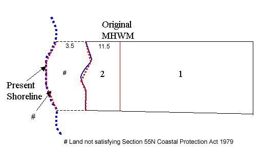
If accretion disclosed in a new survey cannot satisfy the conditions of the Modified Doctrine (either as to sustainability or due to public access issues) the original MHWM must be adopted. The new plan should show the original MHWM as the title boundary together with the PRESENT SHORELINE (shown as broken lines) as determined at that date. The plan should include a table of short lines that details the location of both the MHWM and the Present Shoreline. The accreted land between the MHWM and the Shoreline must be clearly described on the plan with the following notation:
LAND NOT SATISFYING SECTION 55N COASTAL PROTECTION ACT 1979
The position of a former MHWM lost due to reclamation etc that remains a title boundary should be shown on the plan as an irregular line, in accordance with cl.65 Surveying and Spatial Information Regulation 2012, that approximates the position of the original waterfront. A suitable notation should be added to the plan:
FORMER MEAN HIGH WATER MARK (DP....)